
Construction Drawings
Site Plans and Landscapes
Site plans and landscape drawings drafted from your survey: property lines and setbacks, driveways and parking, hardscape, grading references, and planting.
Overview
What are Site Plans and Landscapes?
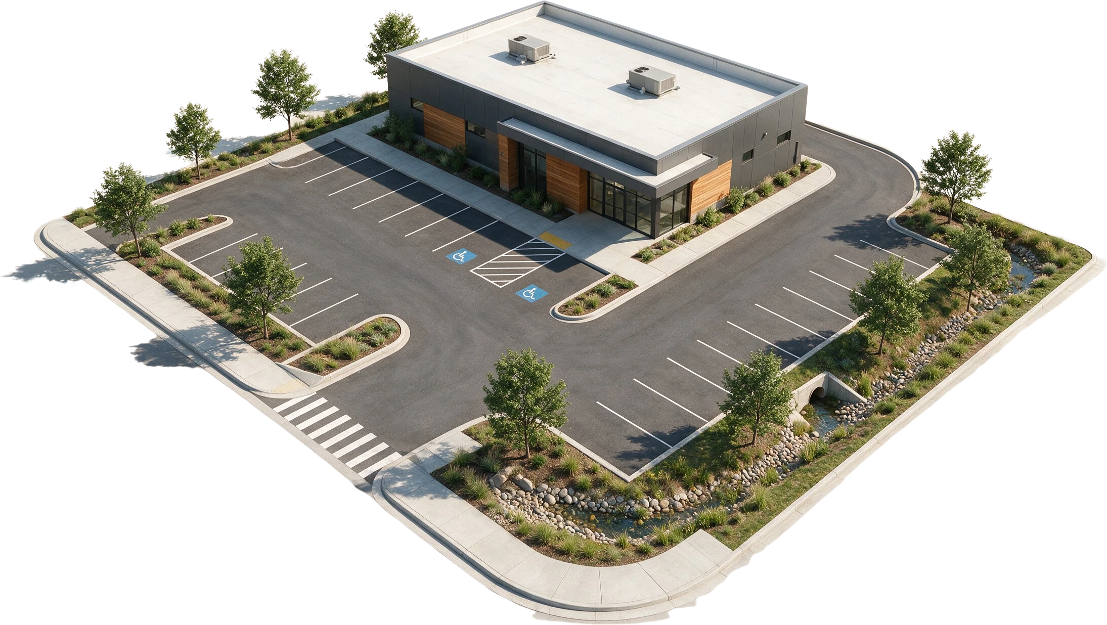
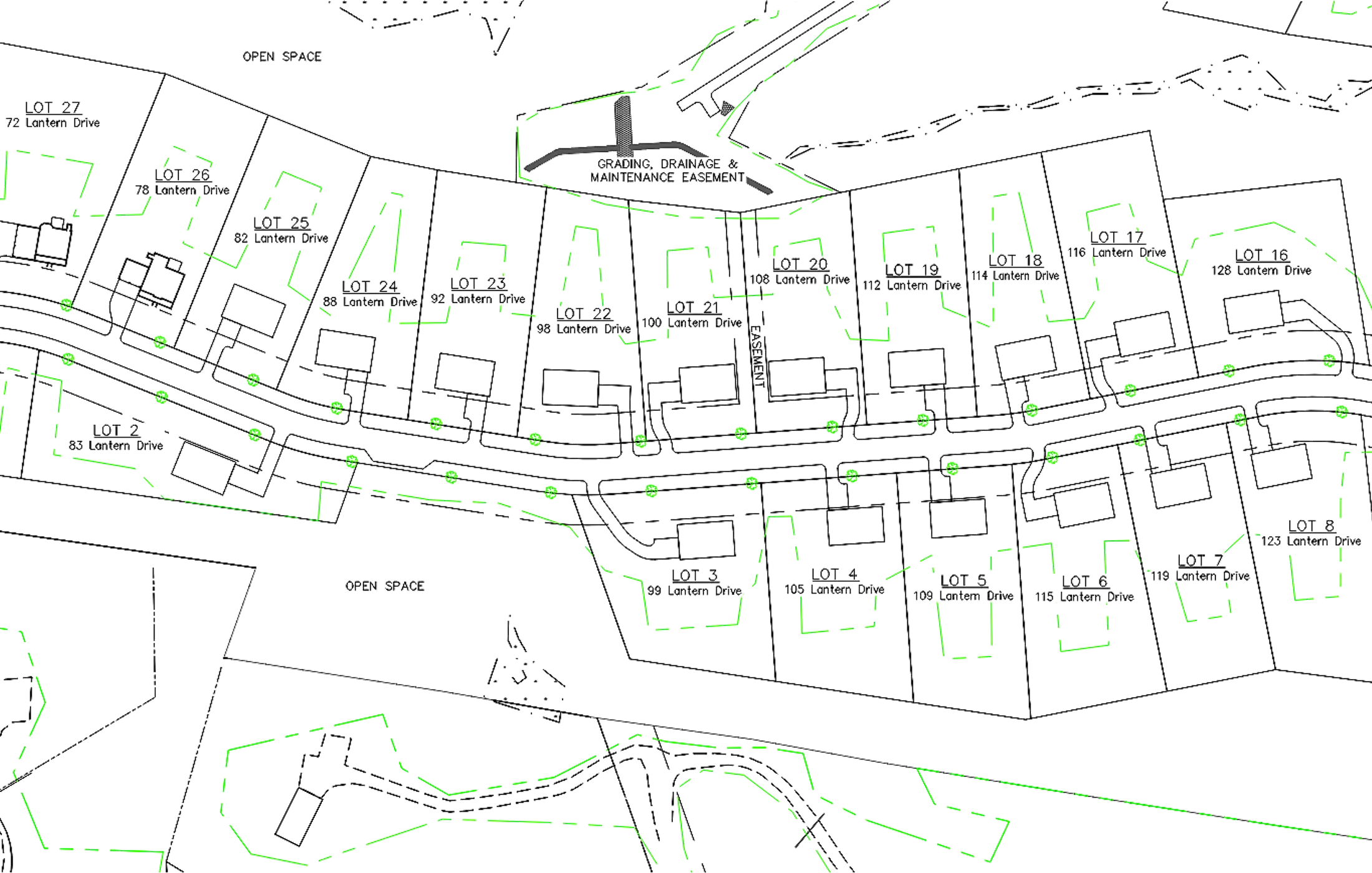
A site plan shows the whole property, including the building and everything around it. It sets out where the property lines run, how far the structure sits from each one, how vehicles and people reach it, and what covers the ground in between. Landscape sheets sit alongside the site plan and carry the planting, the hardscape, and the details that go with them. Together they are the sheets a planner, a zoning reviewer, and a site contractor all read.
Arcengine drafts those sheets from information your team already holds. We take the boundary and existing conditions from your surveyor's file, and the grading and drainage references from your civil drawings. The hardscape and planting follow your design intent, whether it arrives as a sketch, a markup, or a designer's layout. We turn all of it into one clean, coordinated set drawn to your standards in AutoCAD, Revit, SketchUp, or Civil 3D files.
Arcengine is a drafting partner, not a licensed surveyor, civil engineer, or landscape architect. We do not run field surveys, design grading or drainage systems, or seal drawings. Those roles stay with your licensed professionals. We draft to what they issue, so the site sheets stay consistent with the record documents behind them.
At a glance
-
Best for
-
Site plan & zoning submissions
-
Covers
-
Layout, hardscape, grading refs & planting
-
Drawn from
-
Your surveyor's file & civil markups
-
Delivery
-
DWG · PDF · RVT
-
Source
-
Survey, sketches & design intent
What we deliver
What's included in a site sheet set
Each package is issued checked and coordinated: a clean base built on your survey, the site layout, hardscape and paving, planting with schedules, and the details and notes that hold the set together.
-
Existing Conditions Base
Your surveyor's boundary and topography set up as a clean, layered base sheet.
-
Site Layout Plan
Building footprint, setbacks, dimensions, and property line callouts on one sheet.
-
Access & Parking Layout
Driveways, drive aisles, stalls, and accessible spaces drafted to the layout you supply.
-
Hardscape & Paving Plan
Walkways, patios, steps, walls, and paving materials keyed to details.
-
Grading Reference Sheet
Contours and spot elevations carried across from your civil drawings for coordination.
-
Planting Plan & Schedule
Plant locations with a keyed schedule of species, size, quantity, and spacing.
-
Site Details & Notes
Cover sheet, legend, north arrow, scale bar, site details, and general notes.
On the sheet
What a site plan covers
One set of sheets holds the whole property: the legal edges, how people and vehicles move through it, what covers the ground, and the grading references carried over from your civil drawings.
Property lines, setbacks and zoning envelope
Boundary, setback lines, and the buildable envelope drafted from your surveyor's file.
Driveways, parking layouts and circulation
Drive aisles, stalls, and the routes vehicles and people take through the site.
Walkways, patios and hardscape
Paved surfaces, edges, and materials shown with dimensions and callouts.
Grading and drainage references
Contours and spot elevations carried across from the civil drawings your engineer issues.
Planting plans and plant schedules
Where each plant goes, with a keyed schedule of species, size, quantity, and spacing.
Site utilities, lighting and site details
Utility runs, site lighting, and the enlarged details that go with them.
Why it matters
Why are site plans necessary?
Almost every approval starts at the property line. Before a reviewer looks at the building, they check where it sits, how far it stands from each boundary, how much of the lot it covers, and how vehicles get on and off. All of that is read from the site plan, so a thin one holds up the whole submission.
On site, the same sheets tell the crew where to stake the building, where to cut the drive, and what to plant. When layout, hardscape, grading references, and planting all read from one coordinated set, fewer questions come back from the field.
-
It fixes the building on the lot, with setbacks and dimensions a reviewer can measure.
-
Coverage, parking, and access appear in the form planning and zoning reviewers expect.
-
Driveways, walks, and circulation are laid out before anything is staked in the field.
-
The architectural footprint stays aligned with the survey and the civil drawings.
-
Planting and hardscape are set out as a scheduled scope the crew can build.
-
It becomes the reference sheet the whole team returns to during construction.
Where it applies
Industries We Serve
-
01
Architects & Design Firms
Overflow site and landscape drafting that keeps your submission sheets moving on schedule.
-
02
Residential Developers
Lot layouts, driveways, hardscape, and planting for single-family and multi-family sites.
-
03
Commercial & Retail
Parking layouts, access, and site sheets for stores, offices, and mixed-use projects.
-
04
Landscape Designers
Your planting and hardscape concepts drafted into dimensioned, scheduled sheets.
-
05
Civil & Site Engineers
Architectural site sheets kept aligned with your grading and drainage drawings.
-
06
General Contractors
Clear layout and hardscape sheets the field crew can stake out and build from.
-
07
Homeowners & Renovations
Site plans for additions, garages, pools, decks, and yard improvements.
How it works
Our End-to-End Process
01
Collect the Site Data
We gather your survey file, civil drawings, building footprint, and design intent.
02
Set Up the Base
We build a clean, layered base sheet with the right scale, north, and title block.
03
Draft the Layout
We lay out setbacks, footprint, driveways, parking, walks, and hardscape.
04
Add Planting & References
We add planting, schedules, and the grading and utility references from your drawings.
05
Check & Deliver
Every sheet is checked for coordination, then issued in DWG, PDF, and RVT.
Why Arcengine
Why Choose Us
Site Drafting Specialists
A trained CAD team that produces site and landscape sheets every working day.
We Draft From Your Data
Your surveyor's file, civil markups, and design intent drafted faithfully, with authorship staying with your team.
Coordinated Sheets
Layout, hardscape, grading references, and planting kept consistent across the set.
Works to Your Standards
Your title blocks, layers, line weights, and CAD or BIM standards, followed exactly.
Fast, Reliable Turnaround
Efficient workflows that keep your submission and construction dates on track.
Confidential & Secure
Your drawings and project data handled securely and privately.
Explore more
Our Other Services
FAQs
Frequently Asked Questions
A typical set includes the property boundary and setbacks, the building footprint, driveways and parking, walkways and hardscape, grading and drainage references carried from the civil drawings, a planting plan with a plant schedule, and the site details and general notes that go with them.
No. Arcengine is a drafting partner, not a licensed surveying firm. We do not take field measurements or set corners. We draft from the survey file your licensed surveyor provides, and your surveyor stays the record source for all boundary and topographic information.
No. Grading design and drainage design stay with your civil engineer. We carry the contours, spot elevations, and drainage references from the civil drawings onto the site sheets and keep them coordinated with the architectural layout.
Yes. We draft planting plans, plant schedules, and hardscape layouts from the design intent your landscape designer or architect supplies. Design authorship and the landscape architect of record role stay with your team.
Send the survey file or plot plan, any civil or grading drawings, the architectural footprint, and your sketches or design intent for the site. We confirm scale, north orientation, layers, and sheet setup before drafting.
Native DWG or RVT plus print-ready PDF, prepared to your title blocks, layers, line weights, and CAD standards. We also work in SketchUp and Civil 3D files when your team supplies them.
Yes. We arrange the sheets for zoning, planning, and permit submissions, with setbacks, coverage figures, parking counts, and reviewer notes drafted from the information your team provides. Signing, sealing, and filing the submission stay with your licensed professional.
Yes. All project files and drawings are kept confidential and handled securely.
Get in touch
Site sheets, drawn from your data
Send your survey file, civil drawings, and site sketches. We will confirm scale, layers, and sheet setup, then return a coordinated site and landscape set in DWG, PDF, and RVT.