
Land Survey Drafting
Utilities Survey Drafting
Utility mapping and drafting that documents existing infrastructure to support safe design and construction.
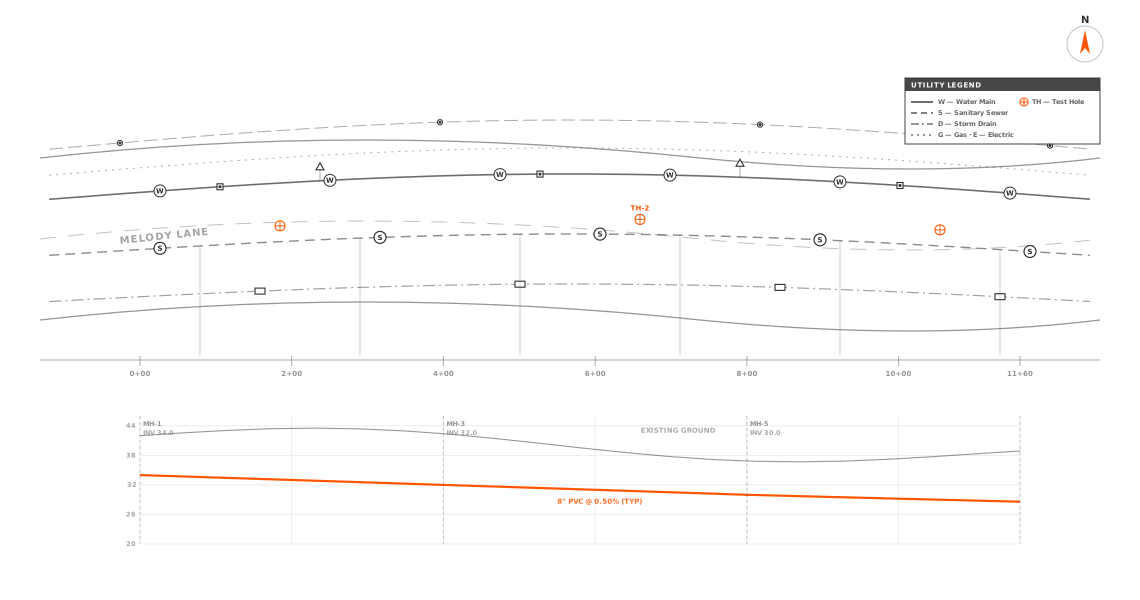
Overview
What is Utilities Survey Drafting?
Arcengine applies extensive expertise in utility design, mapping, and 3D modeling to a wide range of infrastructure projects. Services include preparation of detailed utility line drawings, 3D models, utility pole layouts, and full plans for new installations. Arcengine also prepares accurate as-built documentation of existing utility networks, along with utility drafting for gas distribution systems, electrical networks, water supply, and wastewater management infrastructure.
Underground utility surveying involves mapping subsurface utilities using a combination of geospatial techniques and land surveying methods. It identifies buried services such as pipelines, cables, ducts, and drainage channels through detailed investigation. Growing regulatory requirements, safety considerations, system modifications, complex utility networks, and the need for accurate connection information have significantly increased the demand for complete utility surveys.
At a glance
- StandardEngineering & utility standards
- Best forUtility design & construction
- CoversWater, sewer, gas, power, telecom
- DeliveryAutoCAD DWG · PDF
- Models2D drawings & 3D / BIM
What we deliver
What's included in Utilities Survey Drafting
Each drawing maps the utility networks a project depends on (water, sewer, gas, power, and telecom) for safe, clash-free design and construction.
Underground Utility Layout Design
Preparation of precise layouts for subsurface networks, including water, sewer, gas, electrical, and telecom lines, drafted for clash-free construction and regulatory compliance.
Water Supply & Storage Network Planning
Design and drafting of pipelines, reservoirs, pumping systems, and distribution networks to support efficient water delivery across residential, commercial, or industrial zones.
Detailed Utility Line Drafting
Accurate plan, profile, and cross-section drawings for complex utility corridors, clear for engineers and contractors to read.
Advanced 3D Utility Modeling
Development of coordinated 3D models representing multi-utility systems to detect conflicts, improve visualization, and support BIM-based project execution.
Utility Pole & Overhead Line Mapping
Precise plotting of pole locations, spans, clearances, and alignment for electrical and communication overhead systems, for safe and accurate installation.
Electrical & Gas Distribution Design
Drafting of infrastructure layouts for power supply and gas distribution networks, including routing, equipment placement, and connection details.
Wastewater & Sewer System Plans
Sewer layouts, manhole schedules, flow directions, and treatment connectivity for effective wastewater management.
Stormwater Drainage Design
Design and drafting of stormwater pipelines, culverts, channels, and detention systems to prevent flooding and manage surface runoff efficiently.
Utility Coordination Drawings
Integrated drawings that combine multiple utility systems into a single coordinated plan, reducing conflicts during construction and simplifying approvals.
As-Built Utility Documentation
Preparation of final record drawings reflecting actual installed conditions, essential for maintenance, future upgrades, and facility management.

Why it matters
Why is Utilities Survey Drafting necessary?
Utility survey drafting, also called utility mapping, identifies the existing and proposed utilities above and below ground across a project area. Construction, land development, and infrastructure planning teams use that information to work safely, prevent damage, stay compliant, and make system maintenance easier.
Precise utility drafting reduces the risk of service disruptions, design conflicts, costly rework, and safety hazards during excavation and construction activities.
Accurate mapping of underground and overhead services helps avoid clashes between new construction and existing infrastructure.
Clear documentation of utility locations reduces the risk of accidental damage to gas, electric, or water lines during excavation.
Detailed survey drawings are often required for permits, compliance reviews, and municipal approvals.
Engineers can develop precise infrastructure designs when reliable utility data is available.
Early identification of constraints prevents unexpected field issues, redesigns, and schedule overruns.
Well-prepared records assist in repairs, upgrades, expansions, and long-term asset management.
Where it applies
Industries We Serve
Construction & Infrastructure Development
Supports safe planning and execution of residential, commercial, and large-scale infrastructure projects by mapping existing utilities before construction begins.
Oil, Gas & Energy Sector
Assists in mapping pipelines, transmission lines, and energy networks to support regulatory compliance, safety, and efficient expansion planning.
Telecommunications
Helps in planning underground cables, fiber networks, and communication infrastructure with accurate utility layouts and conflict analysis.
Urban Planning & Land Development
Provides essential data for site planning, zoning, road development, and smart city projects by documenting existing service networks.
Water & Wastewater Management
Supports the design, maintenance, and expansion of water supply, drainage, and sewage systems with precise utility information.
Transportation & Public Works
Essential for highway, railway, airport, and municipal projects to prevent service disruptions and coordinate infrastructure development.
How it works
Our End-to-End Process
Initial Consultation
We discuss your requirements in detail (project parameters, infrastructure, topographic data, existing layouts, and current and proposed utilities) so the scope is fully understood from the start.
Scope Definition
We review everything together to define the project scope, deliverables, technical requirements, and timelines before work begins.
Execution & Drafting
We carry out the technical work, producing detailed utility drawings, 3D models, as-built plans, and infrastructure layouts to your specifications and applicable standards.
Feedback & Finalization
We share draft deliverables for your review, fold in any revisions, and deliver the finalized drawings in your required formats.
Why Arcengine
Why Choose Us
Experienced Survey Drafting Professionals
A team with deep land and utility survey drafting experience delivers technically sound, reliable drawings.
High-Accuracy CAD Outputs
Drawings are developed with strict quality controls to meet industry standards, project specifications, and regulatory requirements.
Advanced Tools & Software Expertise
Proficiency in leading CAD, BIM, GIS, and point-cloud platforms enables precise and efficient drafting for complex projects.
Scalable Support for Any Project Size
Flexible resources let us handle anything from small assignments to large, multi-phase infrastructure projects.
Timely Delivery with Consistent Quality
An efficient workflow keeps projects on schedule without trading away accuracy or detail.
Client-Focused Approach
We communicate clearly, respond quickly, and adapt the work to each project's specific needs.
Explore more
Our Other Services

FAQ
Frequently Asked Questions
Site plans, infrastructure details, topographic information, road layouts, existing and proposed utilities, basic survey data, and any project-specific requirements are typically needed to begin the design process.
Project duration and cost depend on factors such as site area, design complexity, data availability, scope of work, and potential revisions. Detailed discussions during the initial stage help define timelines and budget expectations.
Yes, we can review, update, modify, or improve existing utility plans and designs so they meet current project requirements, standards, or site conditions.
Design and drafting can cover water supply networks, sewer and wastewater systems, stormwater drainage, electrical and gas lines, telecommunications, and other underground or overhead utilities as required.
Final deliverables are typically provided in industry-standard formats such as DWG, DXF, PDF, or BIM-compatible files, so they fit directly into engineering, construction, and approval workflows.
Get in touch
Utility drawings, construction-ready
Send us your survey data, record drawings, and utility info. We'll return coordinated utility plans, profiles, and 3D models in AutoCAD DWG and PDF.