
Land Survey Drafting
Tower Survey Drafting
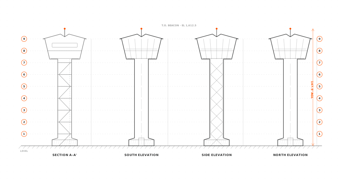
Tower surveys are conducted for multiple technical and regulatory purposes, including assessing tower load capacity and identifying additional structural requirements. Arcengine provides CAD drafting for this complex work, with the high accuracy and clarity needed to prevent costly errors and inefficiencies.
What we deliver
What's included in Tower Survey Drafting
Tower surveys are conducted for multiple technical and regulatory purposes, including assessing tower load capacity and identifying additional structural requirements. Arcengine provides CAD drafting for this complex work, with the high accuracy and clarity needed to prevent costly errors and inefficiencies.
Tower Location & Site Layout Drafting
Preparation of accurate site plans showing tower position, access roads, and surrounding features for planning and compliance.
Elevation & Height Verification Drawings
Drafting of elevation views to confirm tower height, ground levels, and structural clearances.
Topographic Survey Drafting
Creation of contour maps and terrain drawings to represent existing ground conditions around the tower site.
Boundary & Property Mapping
Drafting of property limits, easements, and ownership details affecting tower placement and development.
Utility Mapping & Coordination
Documentation of nearby utilities such as power lines, communication lines, and underground services.
As-Built Tower Documentation
Preparation of drawings reflecting the actual constructed tower and associated infrastructure.
Access Road & Infrastructure Drafting
Mapping of approach roads, equipment areas, and supporting facilities required for installation and maintenance.
Compliance & Permit Drawings
Development of drawings that meet regulatory, zoning, and approval requirements for telecommunications projects.

Why it matters
Why is Tower Survey Drafting necessary?
Tower survey drafting is needed to document the exact location, structural details, and surrounding site conditions of telecommunication towers. These drawings support planning, design verification, regulatory approvals, maintenance, and future upgrades by providing reliable spatial information. Accurate survey drafting lets the project team confirm that the tower installation complies with property boundaries, zoning regulations, safety clearances, and utility constraints. It also helps engineers assess structural stability, access requirements, and equipment placement while minimizing risks during construction and operation.
The drawings also verify that the tower is positioned correctly within property limits and required setback distances to avoid legal or construction conflicts.
Provides essential documentation for permits, approvals, and compliance with local, regional, and national regulations.
Enables engineers to evaluate structural capacity, foundation conditions, and safety requirements before installation or modification.
Identifies nearby utilities, buildings, and physical obstructions to prevent hazards and service disruptions.
Supplies accurate reference drawings for routine inspections, maintenance activities, and future equipment upgrades.
Minimizes design errors, construction delays, and costly rework by providing precise and reliable site information.
Where it applies
Industries We Serve
Telecommunications Industry
Used for planning, installation, expansion, and maintenance of cellular towers and communication infrastructure.
Broadcasting Sector
Supports radio and television transmission towers by providing accurate site layouts and compliance documentation.
Power & Utilities
Assists in mapping transmission towers, substations, and electrical infrastructure for planning and maintenance.
Infrastructure & Construction
Helps in site planning, foundation design, access development, and coordination with surrounding structures.
Government & Defense
Provides survey documentation for strategic communication systems, surveillance towers, and security networks.
Oil, Gas & Mining
Supports communication towers in remote operational areas for monitoring, safety, and coordination.
Transportation Authorities
Used for towers related to traffic systems, rail networks, highways, and navigation infrastructure.
Emergency & Public Safety Services
Enables planning of communication towers used for disaster response, rescue operations, and public safety coordination.
How it works
Our End-to-End Process
Data Collection & Project Requirements
Survey measurements, field notes, existing drawings, tower specifications, and site details are gathered to understand project scope.
Data Review & Verification
Collected information is examined for completeness, accuracy, coordinate references, and compliance requirements.
Site Feature Identification
Site features such as tower location, boundaries, elevations, utilities, access routes, and surrounding structures are identified.
CAD Drafting & Documentation
Accurate site plans, elevations, layouts, and supporting drawings are prepared based on verified survey data.
Quality Check & Final Delivery
Drawings undergo thorough accuracy checks before delivery in required formats for planning, approvals, construction, or maintenance use.
Why Arcengine
Why Choose Us
Experienced Survey Drafting Professionals
Skilled team with strong expertise in tower survey documentation, technical drawings, and telecommunication site requirements.
High Accuracy and Attention to Detail
Precise drafting that reflects actual site conditions, dimensions, clearances, and surrounding features.
Standards-Compliant Documentation
Drawings prepared in accordance with regulatory guidelines, project specifications, and industry practices.
Reliable Turnaround Time
Efficient workflows mean timely delivery for new installations, upgrades, and maintenance projects.
Flexible Support for Various Project Types
Capable of handling single tower sites, network expansions, and complex multi-location assignments.
Secure and Confidential Data Handling
Strict processes to protect sensitive survey data, site information, and project documentation.
Explore more
Our Other Services

FAQ
Frequently Asked Questions
Survey data, field measurements, site coordinates, tower specifications, existing drawings, and project requirements are typically needed.
Common outputs include site layouts, tower location plans, elevations, boundary maps, utility layouts, and as-built drawings.
Yes, drafting services can document current conditions to support inspections, equipment upgrades, and structural modifications.
Yes, documentation can be prepared to meet submission requirements for zoning, planning, and telecommunication authorities.
Drawings are typically provided in DWG, DXF, PDF, or other formats as specified for engineering or review purposes.
Quality checks are performed against verified survey data, coordinate references, and project standards.
Yes, services can support single sites or large network deployments across multiple locations.
Revisions can be incorporated based on feedback so the drawings meet project needs and specifications.
Get in touch
Get Accurate, Standards-Compliant Survey & Drafting Support
We deliver precise CAD drafting, land survey mapping, GIS solutions, architectural planning, and engineering documentation for real estate, construction, infrastructure, and industrial projects.